

Lake Doramos is ENORMOUS. Easily the largest in the world.
Hello from sabmeg!
I only know solid, liquid, gaseous, and plasma. :(
You know more than you might think.
Glass is an other one. Superfluids, Supersolids, condensates, superconductors, you might know as well.
Then there are the others: liquid crystal, microphase, fermionic condensates, degenerate matter, quark matter, color glass condensate, string-net liquid, superglass, chain-melted state, quantum hall state, and photonic matter.
All these newfangled snowflake states of matter! When I was young in 1874 there were only three and we didn’t need any more!
Baltichusets?
i would absolutely play this tabletop setting
The confusion regarding the Midwest is exacerbated exponentially
New Canada implies a possible universe where Canada plans a 3 day special military operation to free the oppressed people of Canada that live within US borders
I ❤️ Shandle
This sounds like a mixture of prescription drugs and made up english towns
The longer you look, the more ridiculous the names are. “Ohio”, what the hell kind of name is that?
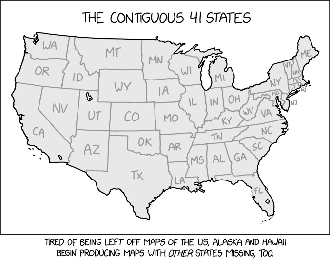
I think the upper right corner should be just all New York.
all my dakotas gone
Honestly, as a European I dare say most Europeans couldn’t name all 50 states, and definitely not place them on a map.
I’m confident I could correctly place Texas, Florida, probably California and maybe Kentucky if the borders were drawn.
Naming more than one or two state capitals? Forget it!
Edit: quite sure about Alaska and Hawaii too, but I forgot those (see!).
Yeah, but the average us-american couldn’t even begin to name the départements of France for example. Or anything on the scale of NUTS1 in Europe or Brazil or China.
The individual states are better compared to medium/small European countries than to districts of most countries in terms of size, population, economy and political independence.
Not being able to place Boise is is more like not being able to place Skopje than Nantes. (And yes, I had to look two of those up)
California maybe, Nebraska not. Catalunya is more significant than over half of the states. As is northrhine-westfalia.
Fellow European, seconding this. I can roughly point out Georgia and New York instead of Kentucky and Michigan is easy because of the coast line. I’ve been to the east coast, I couldn’t point out the state I was in to save my live.
All these straight borders are confusing AF anyway.
Why Kentucky?
as a european its the KFC plate the chef with the big chef hat is holding
Exactly this.
This map brings up so many questions. One could assume that some sort of magic shifted the earth enlarging it, or it’s an alternate reality of some sort. How does politics work in this version of America? This is easily twice the area of the real USA, I imagine it’s basically impossible to govern these lands federally. It’s already difficult enough as it is in reality with all these incompetents in charge.
What would the population look like? Would it be the same in all real states and a proportional amount in new ones? Or would it be more spread out, with urban centers farther apart?
Is there a source for this image? Like, is there a preexisting lore for it? Or can I roll with this and have fun?
London has 12 Grimmauld Place. The US has 88 states hidden in plain sight.
realistically the west coast would either be Spanish or maybe japanese
There’s a high probability that the rest of the world is wider as well… since it seems like the states never grew higher… is there a whole new section at the equator filled with new continents/countries?
Thanks MapGPT
The cost of Trump’s wall is gonna bankrupt us


