maltimore@feddit.org to Desire Paths@sh.itjust.works · 5 months agoThis one's a head scratcher 🤔feddit.orgimagemessage-square34fedilinkarrow-up1367arrow-down17
arrow-up1360arrow-down1imageThis one's a head scratcher 🤔feddit.orgmaltimore@feddit.org to Desire Paths@sh.itjust.works · 5 months agomessage-square34fedilink
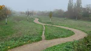
minus-squarefelbane@lemmy.worldlinkfedilinkarrow-up396·5 months agoLow spot on the trail. When it rains, mud pit.
minus-squaremaltimore@feddit.orgOPlinkfedilinkarrow-up86·5 months agoGood point actually, that makes a lot of sense.
minus-squareunexposedhazard@discuss.tchncs.delinkfedilinkarrow-up46arrow-down2·5 months agoOr there was a barrier of sort there before, but now there isnt anymore.
minus-squarericecake@sh.itjust.workslinkfedilinkarrow-up30·5 months agoOh, that’s a good notion. My thought had been that it’s a place where people often stop so it formed a bypass of sorts.
minus-squareglimse@lemmy.worldlinkfedilinkarrow-up4arrow-down3·5 months agoHmmm maybe, but the left is on a slope. The real path is lower, why wouldn’t the rain pool there? Here’s a baseless guess: someone dumped something big on the trail there for awhile and a path formed from the detour and never went away
minus-squareowenfromcanada@lemmy.calinkfedilinkarrow-up47·5 months agoThe real path is the one that floods. When it’s wet, people use the desire path to avoid the puddle.
minus-squareglimse@lemmy.worldlinkfedilinkarrow-up11·5 months agoOhhh!! Duh, I totally misinterpreted that haha. I am fully on board with your theory now
minus-squared00ery@lemmy.worldlinkfedilinkarrow-up3·5 months agoIt’s hard to tell from a picture, but to me, the road looks higher and everything slopes down to the right.
minus-squareglimse@lemmy.worldlinkfedilinkarrow-up5·5 months agoIt is, but I misunderstood what the the person I replied to was saying (even though it was very obvious lol)
minus-squareKing_Bob_IV@startrek.websitelinkfedilinkEnglisharrow-up4·5 months agoIt’s still possible that the main trail is lower in the middle than on its right edge witch would still cause a lot of mud with a good rain
Low spot on the trail. When it rains, mud pit.
Good point actually, that makes a lot of sense.
Or there was a barrier of sort there before, but now there isnt anymore.
Oh, that’s a good notion. My thought had been that it’s a place where people often stop so it formed a bypass of sorts.
Found the hiker.
Hmmm maybe, but the left is on a slope. The real path is lower, why wouldn’t the rain pool there?
Here’s a baseless guess: someone dumped something big on the trail there for awhile and a path formed from the detour and never went away
The real path is the one that floods. When it’s wet, people use the desire path to avoid the puddle.
Ohhh!! Duh, I totally misinterpreted that haha. I am fully on board with your theory now
It’s hard to tell from a picture, but to me, the road looks higher and everything slopes down to the right.
It is, but I misunderstood what the the person I replied to was saying (even though it was very obvious lol)
It’s still possible that the main trail is lower in the middle than on its right edge witch would still cause a lot of mud with a good rain